Download
The Eta Model is a state-of-the-art atmospheric model used for research and operational purposes.
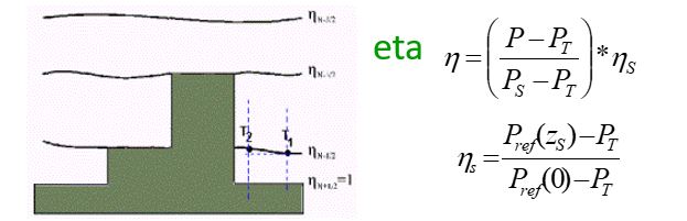
The name of the model derives from the Greek letter η (eta) which denotes the vertical coordinate (Mesinger 1984), one of the model features, defined as
The model prognostic variables are surface pressure, horizontal wind components, temperature, specific humidity, turbulent kinetic energy, and cloud hydrometeors. Model variables are distributed on the Arakawa E-grid.
Major features of the Eta dynamical core are:
- The eta vertical coordinate (Mesinger 1984), resulting in quasi-horizontal coordinate surfaces, and thus prevention of pressure-gradient force errors due to steep topography than can occur with terrain-following coordinates;
- Forward-backward scheme for time differencing of the gravity-wave terms, modified to suppress separation of solutions on two C-subgrids of the model’s E-grid (Mesinger 1974, Janjic, 1979);
- The Arakawa approach in space differencing, with the conservation of enstrophy and energy, as defined on the C-grid, in horizontal advection within the nondivergent barotropic part of the flow (Janjic 1984), thereby enforcing a strong constraint on the false systematic cascade of energy toward smaller scales;
- Energy conservation in transformations between the potential and the kinetic energy in space differencing (Mesinger et al. 1988);
- Piecewise Linear Scheme in the vertical, so model works fully in finite volume.
- Option to run the model in a nonhydrostatic mode (Janjic et al. 2001);
- Lateral boundary conditions are prescribed along a single outer line of grid points. All variables are prescribed at the inflow points; at the outflow points tangential velocity components are extrapolated from inside of the model domain, while other variables are prescribed. There is no boundary relaxation (Mesinger 1977).
Model physics package comprises:
- Convection schemes: Betts-Miller-Janjic (Janjic 1994), Betts-Miller (Betts and Miller (1986), or Kain-Fritsch (Kain 2004);
- Cloud microphysics: Ferrier scheme (Ferrier et al. 2002), or Zhao scheme (Zhao et al. 1997);
- Radiation scheme: SW − Lacis and Hansen (1974); LW − Fels and Schwarzkopf (1975) or RRTMG (Mlawer et al. 1997; Campos et al., 2017);
- Land surface scheme: Noah (Ek et al. 2003) with 12 types of vegetation and 7 types of soil texture, 4 soil layers; or Noah-MP (Niu et al., 2011; Pilotto et al. 2017) ;
- Turbulence and PBL: Mellor-Yamada level 2.5, and Monin-Obukhov similarity theory in the surface layer, with Paulson stability functions.
While the primary use of the model has been for regional weather prediction and NWP type applications (for a review, see Mesinger 2000), the model has been very successful also in regional climate and seasonal prediction applications (e.g., Altshuler et al. 2002, Chou et al. 2005, Katsafados et al. 2005) and climate change studies (Pesquero et al., 2010; Chou et al. 2012; Marengo et al. 2012; Lyra et al 2017).
A more complete list of references can be found on this site.
History:
The model was originally developed in the former Yugoslavia by the Hydrometeorological Institute and Belgrade University (Mesinger and Janjic, 1974). In the eighties, the code was upgraded to the Arakawa-style horizontal advection scheme of Janjic (1984), then rewritten to use the eta vertical coordinate (Mesinger et al. 1988), and subsequently, at NCEP, supplied with an advanced physics package (Janjic 1990, Mesinger and Lobocki 1991). It became officially operational at NCEP on 8 June 1993 (Black 1994; Janjic, 1994). In Brazil, it became operational for weather forecasts at the end of 1996 (Chou, 1996), and operational for seasonal forecasts in 2002 (Chou et al 2005). The model has supported climate change studies since 2010 for the Brazilian Second National Communication (MCTI, 20xx; Chou et al. 2012; Marengo et al. 2012), and in 2014 for the Brazilian Third National Communication. A non-hydrostatic version for high-resolution climate studies was developed (Lyra et al 2017) for urban studies, and also for Small Islands Developing States (Chou et al 2020).
A Global Version of the Model (Global Eta Framework – GEF) was developed (Zhang and Rancic, 2007) and has been used for medium-range, seasonal (Latinovic et al, ASR 2018) simulations.